When I was 8, my parents took us to the Smithsonian Museum of Natural History in Washington DC. They had a hands-on exhibit for kids, where you could handle and play with artifacts from prehistoric races. I still remember the feel of a 1 million year old hand axe. Ever since then, I’ve carried that curiosity and awe of ancient cultures with me.
So when Sharon and I started looking for adventures after our Green River trip, I was excited to learn about Beef Basin. Beef Basin, in southeastern Utah, was part of the range of the Mesa Verde Anasazi, or Ancestral Puebloans as they are now known. It was occupied by farmers for at least several hundred years from 1000 to 1200 AD, and by earlier cultures dating back several thousand years.
Sharon and I spent a week in the Beef Basin area, exploring ruins, hiking, and biking. We drove our 4wd van the Lorax into the southwest corner of the basin, set up camp, and did day trips in the area. With our electric fat tire bikes, we could get to anything within 15 miles in a single day.
It’s hard to believe that ruins of 900 year old farmhouses, granaries, and kivas (spiritual houses) dot the country side in the southwest, preserved by the dry climate, and mostly ignored. Spending time in these places, imagining the lives of the inhabitants, wondering how the lived, and why they left so suddenly is fascinating and thought provoking. Most of the sites have been stripped of any artifacts by cowboys, pot hunters, and archeologists, but a few pot shards remain to look at.
Some sites are documented in the “Guide to Moab Backroads” map book, but many more are out there to discover and explore. After a week of searching, I was starting to see granaries in every alcove, ruins in every sandstone stack of rocks. The discovery of ancient ruins can easily turn into an obsession.
Day 1
We had a bunch of chores to do in Moab – gas, post office, grocery store, etc. and by the time we were done it was 5 pm. We headed south for 40 minutes on Highway 191, then turned west on 211.
At 12 miles in from 191, we stopped at Newspaper Rock, which has over 2000 years of petroglyphs carved by the various cultures that lived or traveled this region. We loved looking at this rock, and it’s visible messages from the past. There are over 650 rock art designs. The drawings are of deer, buffalo, pronghorn antelope, human figures, riders on horses, symbols, and events from the past.
Newspaper rock
We took a very rough road to a BLM campground just off of 211, cooked dinner, watched the sunset, and went to bed.
Day 2 – Family House Ruin
We had heard about a campsite on the southwest corner of Beef Basin, so we made our way there. The drive from 211 was interesting – climbing up over an 8000’ pass, looking north over Salt Canyon, with it’s alternating bands of white and red on the canyon walls, and crossing a few challenging washes where we had to shovel or stack rocks to get across.
When we arrived in camp, we were eager to see a reported ruin nearby, so we hopped out and immediately started hiking around. After 45 minutes of searching, we found the first of what would be over a dozen ruins over the coming days.
We started naming ruins to keep them straight in our heads, and we named this ruin “Family House Ruin”. The layout, courtyard, small kiva, and intimate setting on a small plateau seemed perfect for a family. There was collection of pottery shards set out on a rock by prior visitors for everyone to enjoy – both the corrugated cooking type and smoother, more polished type.
Kivas, by the way, are pit houses used by the male members of the tribe for ritual and ceremony. I believe the predecessors to the Puebloans lived in the pit houses, as they are easy to build, and stay moderate in both hot and cold climages. But as their culture evolved, their houses moved to above ground, and the pit houses took on their ceremonial role.
This was the first Puebloan ruin we had ever visited. I’ve read about and seen pictures and videos of Canyon de Chelly, Mesa Verde, and Chaco Canyon, but I’ve never actually visited Puebloan ruins in person. There’s something wonderful and exciting about finding the remnants of those who were here so long ago. And even more so when the ruin is out in the wild, with no interpretive signs, just left as it was 800 years ago.
This house was well built in its time, but after being exposed to the elements for over 800 years, the roof was gone, and the mud mortar and wall plaster mostly gone.
I think my house would look a lot worse after 800 years than this one!
Family house ruin - the Kiva is at the top right
Day 3 – Big Family Ruin with Granary
We took our first long mountain bike ride today – 20 miles round trip to a ruin mentioned in our map book. The first 7 miles were east on the beef basin loop road, and then we headed 2 miles south, passing through a cattle corral about .3 miles in on the way. Our bikes were pretty quiet on the trail, and we spooked a couple of coyotes.
When the trail ended at the base of a hill, we decided to have lunch before looking for the ruin at the top of the hill. While we were sitting under a tree, I was staring at the canyon across the arroyo below us, and suddenly realized that I was looking at a perfectly preserved granary! A quick look with binoculars, and I left Sharon to explore the main ruin, while I dashed off to climb the canyon wall to the granary.
Sharon reached the main buildings at about the same time I reached the granary. We hollered excitedly to each other across the canyon, but couldn’t make out a word of what each other was saying. I took a look inside the granary, and once inside, realized I had a perfect view of the main buildings across the canyon. I pondered why they would have built a granary up in the canyon alcove when they had such a large facility on the other side, presumably with similar storage rooms. Perhaps as a backup against a catastrophic fire or attack from enemies?
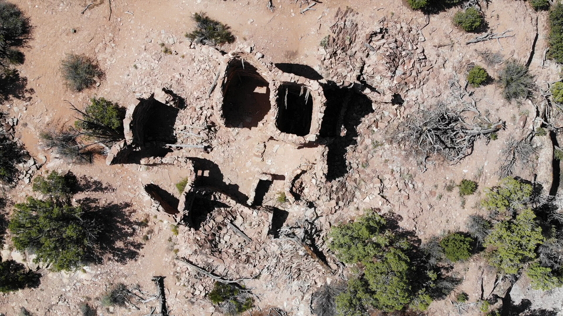
I ran down to join Sharon at the main house, and together we explored its 6 rooms. This site was a bit better preserved than yesterday’s site – two stories of walls in places, door openings and ceiling beams intact, plaster still on parts of the walls. You could still see the fingerprints of the men, women, and children who pressed the mud into place on the walls.
We visited several other ruins on the way back, but this was the largest and most well preserved of today.
Big family house ruin
The granary across the canyon - a fun climb!
Day 4 – R&R
We took a day off from exploring and spent the day in camp, reading and relaxing. I also waded through several thousand photos and worked on my Green River blog post.
Day 5 – Farm House Ruin, Tower Ruin, and Hilltop Ruin
With our first bike venture a success, we decided on a 26 mile round trip ride to an area beyond the north side of beef basin. There were several ruins known to four-wheelers, and as we were to discover, more that weren’t known.
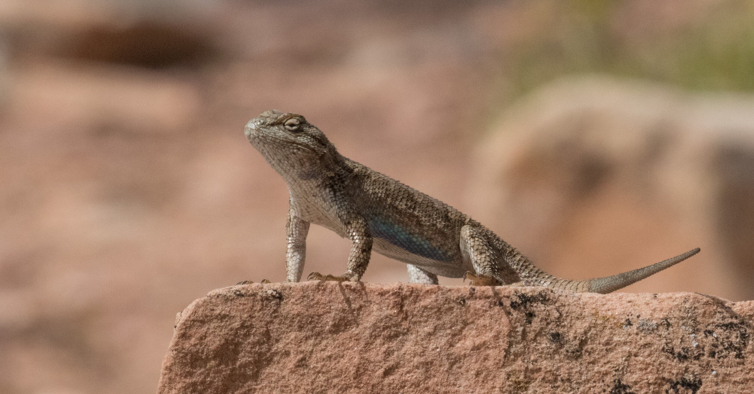
This track was a bit more technical, with more boulder hopping, and deeper sand, but our electric fat tire bikes were a joy to ride, powering us through when my bad knee couldn’t. We also spooked some huge cows, whose presence was visible everywhere on the ground in cow patties and tracks, but seldom seen in person.
Our first stop was Farm House Ruin, but on the way, I noticed an oddly vertical pillar on a distant mesa. Inspection with binoculars showed it to be a partial wall on a hill about 200 feet above the plain. We decided to check it out on the way back.
We made it to Farm House Ruin after about 2 hours of riding. This is well known, with a BLM sign describing the lives of the farmers who lived in the area. It’s quite a large structure, perhaps 30’ x 40’ in size, with the remains of multiple rooms visible. About 100’ east are the remains of what we think was the family kiva.
The farmers grew corn, squash, and beans. The soil was tilled with a pointed stick, and each day the women of the family would carry jugs of water from the spring and hand water each precious plant.
Farmhouse Ruin
About ½ mile further east on the road is Tower Ruin, named after the two story tower that stood here. There is a large kiva directly in front of the house. We liked the view from here, and how the house and grounds were laid out.
Tower ruin
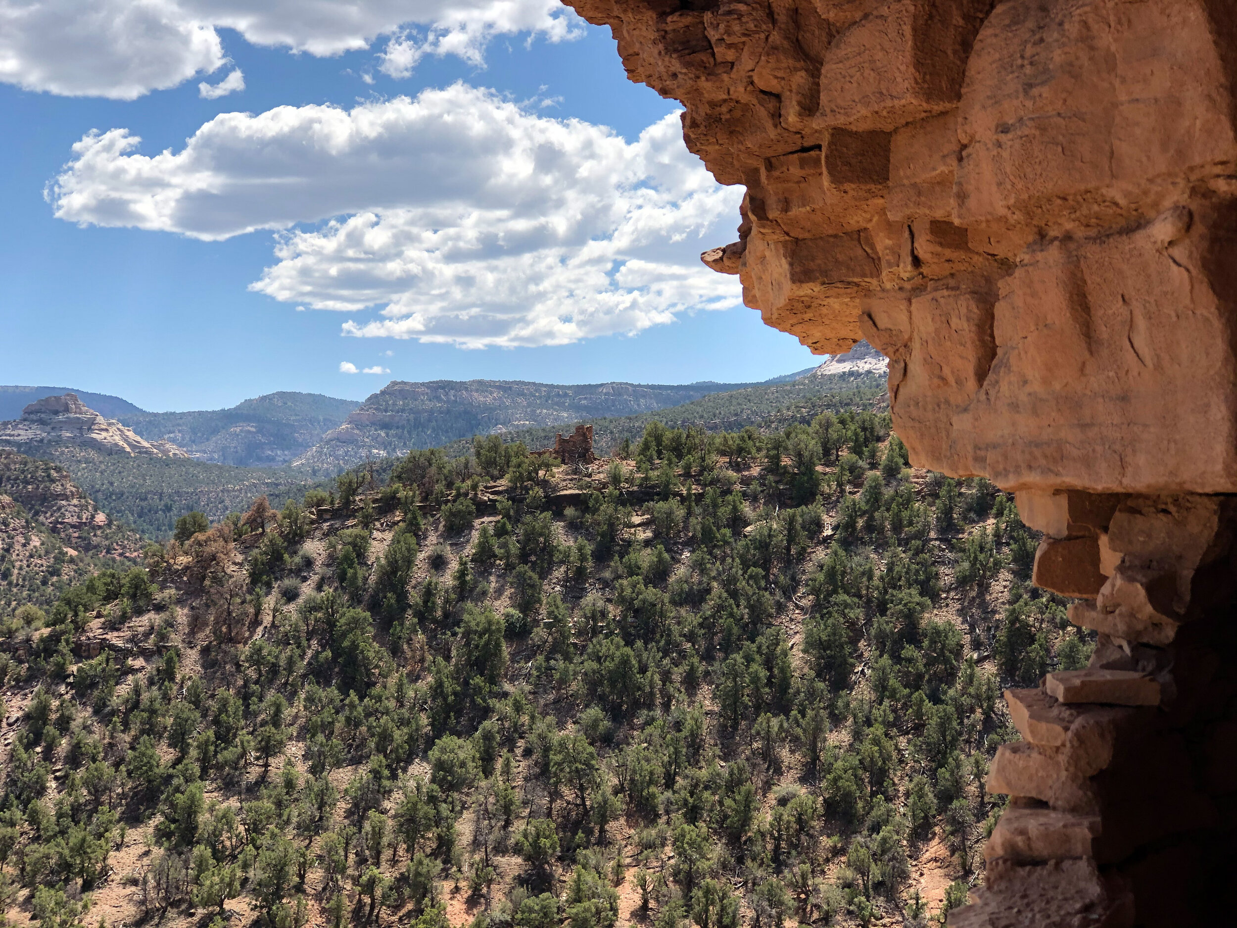
On our return, we stopped to hike to the wall I had spotted earlier on the hilltop. This site appears relatively unknown. It’s visible with binoculars from the 4wd track about ½ mile W x SW of Farmhouse ruin, but there were no human tracks to it. We so enjoyed the site that I made a little video tour. We found (and left) a number of potsherds. From a farming perspective, there is not a lot of arable land around this hill. Its primary value appears to be that it has an excellent 360 degree view of the countryside and with the steep approach all around, easy to defend.
Hilltop ruin
Day 6 – R&R
We took another day off from exploring, although we did do a 2 hour hike to a nearby hill, and found a number of potsherds below Family Ruin, which we added to the collection already there on the stone.
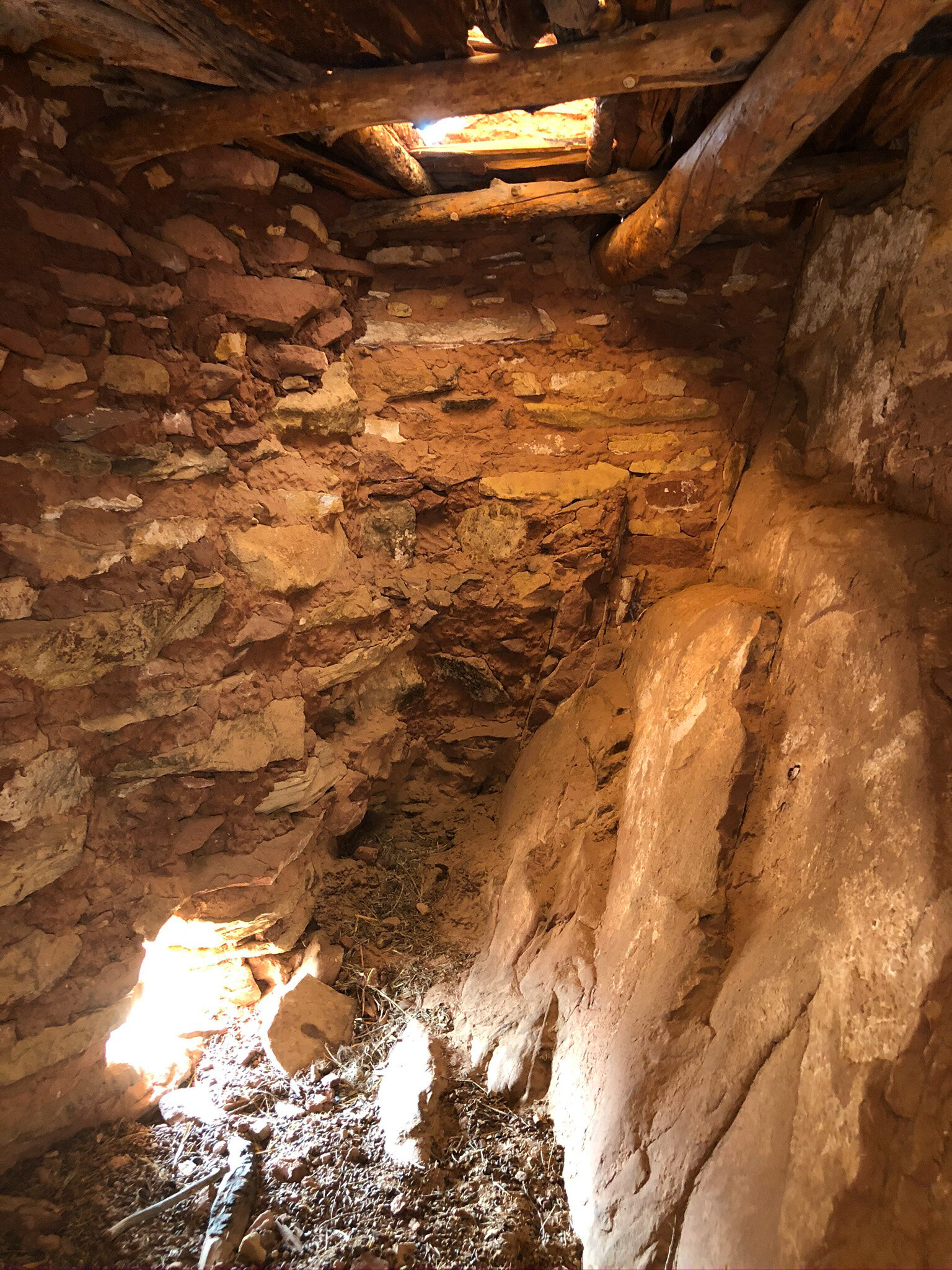
Day 7 - Cliff dwelling
For our last bike trip, we wanted to check out a cliff dwelling that was marked on my 30 year old USGS map, but not on later maps in GAIA. This was another 20 mile round trip ride, with 2.5 miles on a narrow, brushy, and sandy ATV road. I had found an online report of someone who hiked to it. From their description, getting up to the dwelling was risky, with an exposed ledge crawl and a 20 foot drop below. Sharon and I had a discussion about risk assessment, as she was concerned my curiosity would overwhelm my caution. We agreed to assess together, and only proceed with consensus.
The 30 minute hike up to the base of the cliff dwelling was fun, with a bit of bouldering, and great views of the valley below. Once we reached the base, we could see that there were two possible entrances – a narrow ledge with one sketchy area that required handholds on the cliff wall, or a straight up climb of about 15 feet from below. We tried the ledge first, and I had no problem, but Sharon wasn’t feeling confident. Then we climbed up from below, and that worked for both of us.
Once inside, we could see that it was divided into 4 sections, 3 of which have 2 stories. It’s very sheltered by the overhang of the alcove in which it sits. There were no traces of corncobs or pottery shards. The view of the valley below, and of the mountains off to the east is great. Sometimes I think the Anasazi built in these difficult locations just because of the view!
Cliff dwelling ruin - access along the ledge was tricky in spots, easier to climb the face below
Day 8 - Move 'em on, head 'em up!
Rawhide! Ok, I couldn’t resist the cattle reference, what with being in Beef Basin, and stepping around their leavings, and occasionally having stare downs. We packed up and headed out, although once again, staying a few more days would have been welcome. But Sharon had to work, so off we went.
The trip back was uneventful, other than another wash requiring some sand shoveling and rock stacking. The Lorax does really well off road, considering that it’s 19’, with only 8” of ground clearance in a few spots, and weighs about 10,000 pounds. It’s the steep uphill sand parts where it sometimes needs help.
Once back in Moab, we celebrated with some barbeque and laundry.
Where did the Puebloans go?
Around 1250 A.D. there was a mass abandonment of settlements all over the southwest. The questions of what drove people to leave their homes, and where they went to have dogged archeologists from the first discoveries in the late 1800’s.
Perhaps the easiest question to answer is where they went: Modern day Hopi at least, and perhaps Zuni, Acoma, and other tribes in Nevada and Arizona are the direct descendants of these people. But why they abandoned the Colorado plateau and migrated south is not certain.
What is known is that drought hit this area around that time, that arroyo cutting from storms was dropping the water table, and that the game was increasingly hard to find. So there were environmental pressures making life more difficult.
At the same time, their relatives to the south were developing what we might think of today as a more socialized approach to living. This approach – sharing of resources, and banding together in stronger and larger communities, made living in the harsh environment easier. These folks were also developing a religion based on Kachinas – hundreds of intercessors to the gods – and the pull of the stronger, more religious communities may have contributed to the abandonment.
Responsible travel
It took some effort to be responsible travelers in the desert here.
Mature biotic soil - easy to kill!
The hardest thing was exploring without damaging the soil. Unlike our native Northwest, there is no real topsoil here, other than a thin layer of bacteria, algae, and lichen in the top 2-3 inches of soil. If you step on it, it dies, and regeneration takes from 10-150 years, depending on location. All other plants depend on this thin layer to plant their seedlings, so it’s easy to turn an area with living plants back to dead sand. We walked on established trails (both human and animal), dry creekbeds, or hopped from rock to rock.
For the ruins themselves, we touched almost nothing, and left everything as we found it. We did take the liberty of putting potsherds found on the ground with other previously found potsherds for the enjoyment of future visitors. This does disturb a site somewhat, but we seriously doubt any architecture work will ever be done on the thousands of sites dotting the landscape.
It is ironic that at the same time we and many others are taking these precautions, 2000 pound cattle are roaming around stepping on everything. But that’s the contradiction of our times.
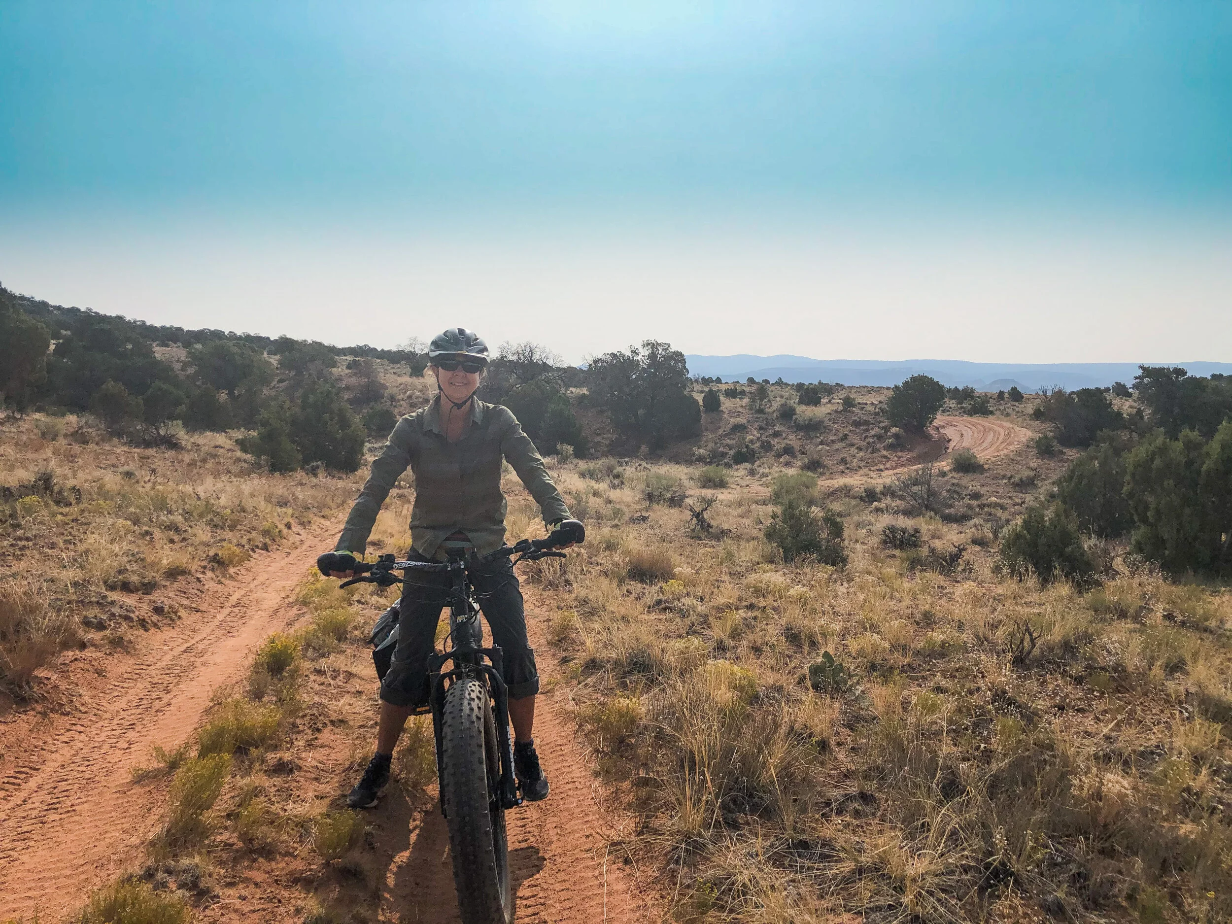
Mountain bike riding
Sharon on her fat tire electric mountain bike.
We parked when we arrived, and rode or walked everywhere. There are some stretches of road or ATV trail with deep sand, but our fat tire bikes mostly did fine in the sand, even loaded with lunch, camera gear, and water. I will say that both Sharon and I spent some time laying on our sides in the road after wiping out in deep sand. If you have skinnier tires, expect to do a fair amount of pushing (no fun uphill in sand!).
Getting there
You’ll need at least a stock relatively high clearance 4wd vehicle, ideally with low range. I’m guessing a Subaru could make it, but it might take some under carriage damage without some rock stacking.
We used the “Guide to Moab Backroads” book for detailed directions.
From Moab, drive south on Highway 191 about 40 miles and turn right on Highway 211.
Continue west 20.3 miles and turn left on Cottonwood Canyon Road, C.R. 107, at sign to Beef Basin. Look for vault toilet.
At this point you can go left or right to enter the south or north side of Beef Basin. We went north.
Resources:
I highly recommend this book for the clear directions, GPS waypoints, and notes on trail conditions, views, and ruins.
GAIA GPS with National Geographic map layer.
We use GAIA for hiking, biking, boating, and back country driving. Indispensable.
In Search of the Old Ones – David Roberts.
An engaging read by a guy who is really obsessed with the Ancestral Puebloans, along with some thoughts on the ethics of archeology, pot hunting, and exploration.
A Naturalist's Guide to Canyon Country (Naturalist's Guide Series)